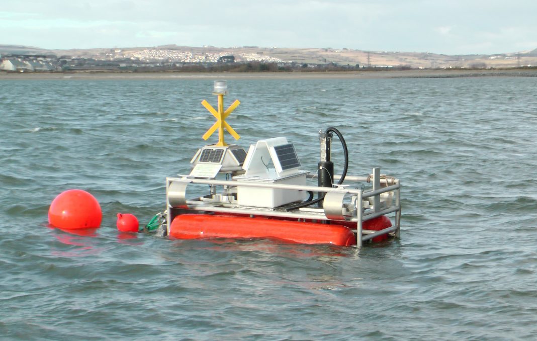
Estuaries on the west coast of Wales represent some of the most challenging conditions for environmental monitoring. However, staff from monitoring solutions company YSI Hydrodata and Environment Agency specialists have combined to develop a solar powered water quality monitoring pontoon which is providing 24/7 data that previously would have been an impossible dream.
Background
The pontoon was installed in March 2010 and the Environment Agency’s Ian Myers says “a number of technical innovations have been deployed on the pontoon which have helped to deliver an unprecedented volume of water quality data that has made a major contribution to our understanding of water quality conditions in the area.”
YSI water quality monitoring buoys are in operation all over the world. However, Environment Agency staff needed to monitor estuarine water quality continuously in a particularly challenging environment – the Burry Inlet near Llanelli in south west Wales. With a tidal range of over 8 metres in a narrow channel, a pontoon was chosen to reduce drag in high flows and to provide the monitoring equipment with greater protection.
Commenting on the challenging conditions, YSI’s Darren Hanson says “We would normally recommend a ‘YSI Pisces’ catamaran for applications such as this, but Environment Agency Evidence staff were able to combine existing resources with a great deal of ingenuity to save money on the platform. This meant that a greater proportion of the budget could be allocated to the variety of equipment and instrumentation supported on the platform”
The Burry Inlet is located between the north coast of the Gower Peninsula and the south-east coast of Carmarthenshire. The large estuarine complex (6,628 hectares) is composed of extensive intertidal sand and mudflats, a large sand dune system, and the largest continuous area of saltmarsh in Wales (2,200 hectares). The estuary is fed by three main rivers; Loughor, Lliw and Llan.
Since Roman times, Burry Inlet has been an important cockle fishery, providing food and work for local people. However, mass cockle mortality in recent years has resulted in an investigation that has yet to identify the cause of the cockle deaths. In addition to helping the Environment Agency to undertake its statutory monitoring duties, the monitoring pontoon is also providing a wealth of data to support the ongoing investigation.
Stuart Thomas is Project Manager, Burry Inlet Investigations for the Environment Agency Wales. He says “There has been a strong underlying improvement in the Burry Inlet over the last 20 years; the water quality is good and the trend is for further improvement. The addition of the monitoring pontoon has helped us to record water quality at a far greater frequency, which is particularly beneficial in estuaries because of the changes that take place during the tidal cycle and extreme weather conditions.”
The Pontoon and Instrumentation
The pontoon was designed and developed by the EA’s Innovation Team in Evidence and has an aluminium frame, is fitted with two solid foam floats and has a keel made from a heavyweight chain, which keeps it upright. The design has been adapted with a hydrofoil (a streamlined wing structure) to allow it to lift out of the water in high currents. It was successfully tested before deployment in the estuary by towing against the flow in the river Avon near the Environment Agency’s Bath office. The water quality monitoring sonde (YSI 6600V2-4) is protected by purpose built retractable tubing which enables the monitoring of shallow waters and protects the sonde if the pontoon rests on a sand bank.
A water-tight telemetry box was originally fitted with 2 x 10W solar panels. This is fixed to the top of the pontoon and contains the GPS-GSM buoy tracker, a 12 volt 38aH battery and power supply and YSI Econet ‘Data to the Web’ telemetry equipment.
The mooring consists of a medium sized fluke anchor and 1.5m of very heavy grade chain. This is attached to approximately 15m of lighter galvanised chain that rises to the surface which, in turn, is attached, via a cleat, to a large fishing float which is designed to take the weight of the mooring.
If the pontoon moves a certain radius away from its last known position, it will alarm by sending a text message to a pre-programmed phone number.
Water Quality Monitoring
Traditional water quality measurements by routine boat patrols are costly, time-consuming and represent a higher level of risk to staff. Occasional measurements also fail to reveal the majority of water quality events that might take place as a result of tidal cycles, storms or pollution incidents. In contrast, the YSI sonde is set to take measurements from a range of sensors every 15 minutes. This means that the sonde is able to store as many readings in just one day as a monthly boat would collect in eight years.
Sonde data are stored on an internal datalogger and also transmitted via YSI Econet telemetry to a dedicated website.
There are two sondes (YSI 6600 V2-4), duty and standby; both of which are fitted with sensors for the measurement of conductivity, salinity, temperature, pH, oxidation-reduction potential (ORP), dissolved oxygen (using the ROX™ optical DO sensor), turbidity, chlorophyll, and blue-green algae. The turbidity, Chlorophyll, DO, pH and ORP sensors are provided with wiped fouling protection.
The YSI sondes have been designed for long-term deployment with minimal maintenance and calibration requirements – approximately four times per year. Commenting on her experience with the sondes Carol Terrill from the Agency’s National Laboratory Service based in Llanelli said: “The use of a sonde guard covered with copper tape did reduce barnacle growth, but a lot of barnacles still had to be removed at the end of each deployment. The decision to switch to a copper alloy sonde guard, part way through the deployment although in early autumn resulted in zero barnacle growth on the sonde guard. We also noticed that fitting a copper mesh screen to the conductivity probe prevented barnacles from getting inside the conductivity cell. The probes all seem quite robust and stood up well to the battering they received during storms.”
The benefits of continuous data
Collection of data obtained remotely from the pontoon is a far safer method of monitoring and allows water quality to be monitored during storm or pollution events that may otherwise be missed by routine boat patrols.
Ian Myers believes that monitoring system at Burry Inlet has made a radical contribution to the understanding of water quality conditions in the area. “We now have instantaneous access to almost live data in addition to an archive so that we can identify trends,” he says. “We can also check the status of the monitoring equipment itself, which helps to optimise servicing and data quality.
“The sonde wiper systems, copper guard and copper tape have all extended deployment times and the DO, salinity, conductivity, pH, temperature and algae readings are cross-checked with spot samples taken from the boat; which further improves confidence in the data.”
Looking forward
The data from the pontoon has corroborated the boat monitoring and also provided greater insight into the changing conditions within the estuary over tidal and diurnal cycles. As monitoring continues, the Agency and other interested parties will be able to plot water quality over a yearly cycle and to detect pollution incidents as they occur. As a result, stakeholders will be able to apply more detailed scientific data to water related issues in the Burry Inlet.
Ends
Words 1,229


